Tuesday, 11 June 2013

The Yorkshire Dales and Cumbria

Wednesday  5 June.
2pm and I am at Chesterfield railway station ready to begin the 14-mile ride to Hathersage. The station is not the lowest point in the town but it is still an uphill pull before I am within the shadows of the crooked spire. There are many opinions as to how the spire became twisted but I can reveal the truth. It was a dark and stormy night (it is always a dark and stormy night in these stories). Let me begin again. It was a dark and stormy night and an elf was flying home, cold, wet, and tired. He arrived at Chesterfield and rested on top of the tower. Being lost he held on and leaned out look for a sign to tell him were he was. The spire has been twisted ever since.
Of the 14 miles I have to ride, nine of them are uphill. Mostly gently uphill but for the final two miles, before I arrive at Owler Bar. Here is a large one-way road system, three quarters of a mile all the way round, right on top of the moors. Even in the 1960's this seemed under-used but it must be remembered that it was built before motorways came along and this was the main artery for goods from the manufacturing towns of the South Riding to the industrial cities of Manchester, Liverpool and the north west.
From Owler Bar it is a white-knuckle ride to Hathersage, down hill and sweeping bends. Unfortunately the hill finishes in the centre of the village, which is always busy with traffic and rather slows down the ride.
After a meal in one of the cafes I am across the road and booked into the hostel, a large house overlooking the village.

Thursday 6 June
I started later than I had intended to-day but make the most of the flat roads along the Hope Valley before turning into Bamford and across the head of Ladybower dam. That is the last I will see of flat roads to-day - in fact it is probably the last I will see of flat roads for the next two weeks.
A steady climb takes me over Strines Moor. There are some stunning views along this route which passes moorland and reservoirs, this is Derbyshire at it's best. There are also some very steep hills, this is Derbyshire at it's worst!
After a short and very busy section of main road I am into Yorkshire and the 'Last of the Summer Wine' village of Holmfirth, after which I descend to the village of Meltham. I enjoy many happy memories along with my lunch break, I lived in the village for six years and the surrounding area is outstanding - well worthy of the name 'God's Country'.
The roads are now hard work into and out of the steep sided valleys before I reach Scammondon dam and cross over the M62 motorway. At Ripponden I am reduced to walking uphill.
Within sight (well almost) of my destination the road is closed. Not just closed but cyclists can get round, closed full-stop. This means a deviation which takes my down to the Calder Valley floor via a collection of steep, narrow roads surfaced with the original cobbled setts. I walk the final section as there are large pieces missing.
It is now a main road ride through Mytholmroyd and Hebden Bridge to Toddmorden before I can cross the river and climb to the hostel in the village of Mankinholes, high on the valley side.
The hostel is a converted stone-built manor house offering first rate accommodation. I have been on the road (including breaks) for eight and a quarter hours but have covered only 56 miles - I am in bed at a quarter to nine.

Friday 7 June
Out of bed at 8 o'clock this morning, after 11 and a quarter hours asleep.
The direct route to Haworth to-day is around 15 miles, in order to stretch it out a bit I have added and extra section over the moors.
The sweep down to Hebden Bridge is good this morning, although care is needed on the twisting roads. The easy ride soon comes to an end as I take the road to Heptonstall - it goes up and up, getting steeper as it goes. In the village itself I am again reduced to walking over cobbled setts. By the end of the town I don't feel as though I want to get back on the bike again.

 
The ride over Heptonstall Moor is enjoyable, rolling countryside, a smooth road surface and remarkably, no fast-food wrappers. Maybe the 'no-brainers' think it is a no-brainer to come up here to dump their rubbish.
After a break in Trawden I turn back on myself and aim for Haworth over Dove Stones moor - which does have a trail of fast-food wrappers.
A lunch-time arrival gives me chance to see the stream trains on the Worth Valley railway.  On my way to the hostel at Longlands Hall I discover a rather 'personalised' front garden. Talking with a passer-by it seems the owners take everything in over the winter and bring them out again in the spring - must be a task to cut the grass.

 
Longlands Hall was built in 1884 for the owner of a  Worsted mill. Over the years it has seen many uses including a hostel for immigrant mill girls during the second world war. Renovated to it's original condition it offers terrific overnight accommodation.


Saturday 8 June
With only  a 14-mile journey to Earby to-day I am in no hurry to depart, this could in part be my reluctance to climb the steep hill out of Haworth.
I have to follow my route of yesterday back towards Colne so the steep hills I toiled up are now the easy freewheel rides to-day. By the same count yesterdays freewheels are to-days hard climbs! With a tail wind I make good progress, even sprinting up some of the hills.
Who in their right mind drives out here into the hills to dump a bath? 


After a break in Colne I continue over the moors to Earby. I had always imaging this to be a sleepy little village, but viewed from above I see a small, former cotton producing town with row upon row of terraced houses and several factories with tall chimneys. Whether the factories still produce anything is another question. I may be doing the town an injustice, if I am I apologise, but it seems as though the heart has gone out of the place.The hostel is on a quiet edge of town. Just the opposite to last nights Longlands Hall this is a small terraced cottage. Previously the home of Katharine Bruce Glasier, a pioneer of the labour movement, being a founding member of the Independent Labour Party in 1893 and who became the only woman on the first administrative council.


Sunday 9 June

The sky is overcast as I leave this morning on the 28-mile journey to Malham. The hills are now much more forgiving and I ride through Hellifield  to take a look at the railway station. Opened on 1 June 1880 by the Midland Railway it had, and may still have, the longest continuous cast iron canopy in the country. It was restored to it's former glory during 1994 but is now looking ready for more care.


My lunch stop to-day is the Dalesman Cafe in Gargrave which has long been a magnet for local cyclists. To-day is no exception and it is almost 'standing room only'.


From here I have a steady six miles to the hostel at Malham. This was designed by and dedicated to the architect and town planner John Dower who spent a large part of his life pressing for the establishment of the Peak District National Park, the results of which we now all take for granted. The hostel is a fitting memorial.
Monday 10 June
I am happy to set off in cooler temperatures today but son get warm after one and a half miles of a 1-in-7 gradient out of Malham. It is a hard climb but whilst stopping at the top for a drink I can see the three peaks of Ingleborough, Whernside and Pen-y-gent. Just me, the view and a flock of curlews. What a way to start the day!
On the run down to Settle I am covering a long straight section at just over 40mph when, as a round a bend, two events cause me to loose speed. One is a flock of chickens in the road the other is a sign telling me I am about to go uphill again at 1-in-7. 40 to three in a few yards.
After Settle a single track road takes me into Lancashire and the scenery changes almost immediately to wide valleys, woodlands and rolling hills.
Slaidburn is a very quiet village with not a lot other than a pub, a post office and the hostel - a perfect location in fact. An old coaching in the hostel retains it's stables and has very cosy and comfortable rooms (not in the stables!).


Tuesday 11 June
Leaving Slaidburn this morning I can see rain over to my left in Forest of Bowland but the road ahead of me is clear. I do feel a few spots as I ride down to Wigglesworth and Settle but nothing to get worried about.
Luckily from Settle to Ribble Head I have a tail wind. It does not help on the uphills but makes riding along the flat very relaxing.
Weather in the high Pennines can change very quickly, as it can in all mountainous regions. For this reason whenever I am am at Ribble Head I always check with the weather forecasting board outside the Station Hotel.
 
 
Turning towards Hawes for the final 11 miles of my ride I now have a cross wind, making riding very difficult up and over Newby Head from where the road is generally (but not always) downhill to Hawes.
 
 
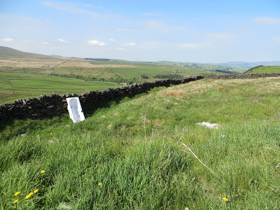
This is the county boundary marker at Newby Head. Just to the right is a new sign stating 'Welcome to Richmondshire'. How many new counties can we invent?
No visit to Hawes is complete without a meal at the 'Chippie Cafe'. You will go a long way to beat their fish and chips, in fact you will go so far you will probably be coming back round from the other direction.


During the evening I stand in the lounge of the hostel and watch the light fade over Stag Fell, a beautiful evening.
 
Wednesday 12 June
By contrast to last night, this morning I am unable to see Stagg Fell through the rain, which eases off a little by the time I am out of the door and pointing in the direction of Garsdale Head. At Garsdale station I cross into Cumbria and the route immediately begins to point downhill as I pass Wild Boar Fell, already I like Cumbria.
In Kirkby Stephen I am glad I have only sports energy drinks in my bottles.
 
 
Further into the ride I spot four portable toilets on a grass bank by the side of a river. I take it this is a popular local beauty spot, judging by the piles of litter I am probably correct. It turns out to be the Eden Valley.
Arrival at the village of Dufton is just after mid-day, giving me the afternoon to ride to the summit of Great Dun Fell. At 2,067 feet this is the second highest mountain in the Pennine range and due to having a satellite tracking station on the summit has a tarmac road all the way. The ride involves climbing for just just under four and a half miles. The cloud-base comes in at 1,400 feet so forget sight-seeing, just keep going. There are some steep sections but most of it is just hard. The summit has an average of 114 days per year of gale force winds and to-day seems one of those days. I am told on a clear day it is possible to see as far as the Isle of Man, I am lucky to see across the road. On the way back the view, once I get below the clouds is outstanding, even though I cannot see the coast.
All the hard work has given me an ideal appetite for a meal and bed at Dufton hostel.
 
Thursday 13 June
This morning I make a detour on my route to Alston in order to look at 'Long Meg and her Daughters' (62 of them). A stone circle, (apparently) second only in importance to Stonehenge. The story is that the girls were turned to stone after some indiscretion, it must have been some party.
 
 
Continuing on my way to Alston the route takes me over Hartside Summit. As my approach is from steep country lanes by the time I reach the main road all the hard work is done, and it is a steady climb to the top, then a long freewheel to Alston.
 
 
After a break for lunch the next challenge is the appropriately named 'Killhope Summit', near Nenthead. At 2,057 feet it shares equal first place as the highest through tarmac road in the country.
 
 
Downhill into County Durham I achieved a personal best, freewheeling at 48 and a half miles an hour - shortly after I reach another 48 on a bumpy country lane on which I should not have been going at that speed. Over the moors in Weardale was hard work and I admit that near Rookhope I again reverted to walking. After a mile or so in Northumberland I was back into County Durham and to the hostel at Edmundbyers. Built in 1800, in 1851 it became the Moorside Inn and a Youth Hostel in 1936. On my last visit here I fell asleep in front of a large open fire. That has now gone and been replaced by central heating.

 
Next door I found more interesting garden ornaments.


 Friday 14 June
With only 20 miles to ride to Langdon Beck to-day I am in no particular hurry to leave. When I do set off I am going nowhere fast due to a headwind, but with the views I have over Weardale, who cares. As I reach the top of a hill I find I have been riding for 45 minutes and covered five miles. Down the other side I am having to pedal hard to reach nine miles an hour.
In the village of St John's Chapel I begin the other equal first place in the contest for the highest through tarmac roads. This is an unclassified road, again to 2,057 feet. The hill goes up in a series of plateaus, which gives me something to aim at and a place to rest after a continuous fight with the headwind. Some of my stops are only a quarter of a mile apart and the whole climb takes almost an hour. From the summit I can see the weather closing in and by the time I reach Langdon Beck hostel three miles latter I am in pouring rain.
After a hot shower I begin to enjoy my meal looking over Cronkley Scar in beautiful sunshine, which turns to rain then back to sun before I have finished eating.

Saturday 15 June
Another round of rain/sun/rain this morning before I set off towards Middleton-in-Teesdale. The first five miles all generally downhill and I run them off at an average of 18.5mph. If not heading for the sun at least I seem to be leaving the rain behind. So much for that idea, at Middleton-in-Teesdale I have to stop to put on wet-weather clothing before I continue to my first break of the day in Barnard Castle.
From here I have a tailwind and quite flat roads for the next two hours before I decide to take a break in the village of Brompton, near Northalerton. As I stop outside a shop there is a notice on the door 'No hoods, No hats, No helmets, Do Not Lean Bikes on Window'. All for good reason I am sure, but I decide to ride the extra two miles to Northalerton and eat there.
The ride then takes me over the busy A19 road and a walk over a bridge to avoid a ford (I have fallen off in these before) and along through quiet and hilly lanes to the village of Osmotherley, on the edge of the North York Moors, where the hostel is in a converted linen mill building.

Sunday 16 June
After once again walking over the bridge to avoid the ford I am out onto the A19 for about two miles, which has quite a wide hard shoulder, before I can turn off into the quiet roads. After three 16% climbs in quick succession I find my legs have gone when I reach flat roads. Time for a drink and food after only seven miles.
The hills gradually get smaller and after the village of Crayke I can see the Vale of York opening out before me - flat roads at last! With 40 miles covered I am in the city of York and am greeted by the aroma of warm chocolate as I pass the Nestle (formerly Rowntree's) chocolate factory. Pleasant in the short-term but probably not if you live with it 24-hours a day.
The hostel here is a large house, re-opened in April this year after a £2 million  refurbishment. What a comfortable and relaxing place it is, sitting in the lounge looking out over the garden through a glass wall.
The route to the hostel is along the river bank - dismount? I think I will!


Monday 17 June
An interesting ride out of York this morning, through back streets and cycle paths, until one path is closed and the diversion signs are not entirely accurate.
From York to Beverley, apart from the main road there is no 'direct' alternative. It is either a loop north or a loop south. After planning my routes onto the GPS almost a month ago by this time I have no idea which option I have chosen. I looked at a map last night but still could not remember! Eventually arriving at Market Weighton it seems I have chosen the 'southern' option.
The hostel at Beverley is in the Minster Priory and although the facilities have been modernised the building retains it's original character and is an experience to stay in.

Tuesday 18 June


Leaving Beverley on country lanes I suddenly find I have routed myself along a farm track 'No Unauthorised Access' and a rethink is necessary involving a ride to the outskirts of Hull before picking up my original route at Hessle just before the Humber bridge.
I had intended to ride straight over the bridge and get something to eat in Barton-on-Humber, due to the very poor quality of the cafe at the bridge visitor centre. However, as luck would have it, the cafe has closed down to be replaced by a catering caravan, which offers much better service at much better cost.


The Humber Bridge - I'm almost home !
 
Over the bridge and just after Humberside airport the road is closed - more 'navigation-on-the-fly' in order to reach Caistor. If anyone tells you Lincolnshire is flat, do not believe them. From here to Louth I have to cross a range of hills that cuts diagonally across the county. Not Yorkshire/Cumbria hills, but hard work all the same.
Tonight I am making for the 'Woodys Top' hostel near Ruckland. A converted barn that only had running water installed  in 1988. To-day it is a most comfortable place and I was able to spend part of the evening watching hares playing in the garden, not exactly 'boxing' but not far off.


There cannot be many road signs left like this one to indicate the youth hostel

Wednesday 19 June
Once again a hilly start to the ride on the way to Horncastle and Woodhall Spa, which proves, after 15 miles, an ideal place to stop for food. From here on the road is pan-flat and straight as a die, to the extent that when a corner comes I find it interesting. In the village of Martin I find an interesting stone above the door to the old blacksmiths cottage. As I am taking a photograph the lady owner invites me in to show me around the house!


After this another navigational problem occurs. At Cranwell the route is closed by a barrier, it turns out the area is an RAF base with signs to the effect of 'clear off or else'. The driver or a large lorry is having the same problem, but it is easier for me to cycle half a mile back along the single track road. The revised route takes me along the busy A17 Newark to Sleaford road, the very road I had been trying to avoid, but I am soon around Cranwell and back on route and my way to the village of Thurlby. The hostel here is a country house, gifted to the Youth Hostels Association in 1979 and at the centre of an area rich in historical, cultural, architectural and natural interest.
Thursday 20 June
To avoid the busy A19 road to Peterborough I put in a short deviation this morning. The roads are quiet, flat and I have a tail wind - what more can I ask? After crossing the A47 and the A1 at Wansford the terrain becomes more hilly but offers a pleasant ride through villages of mellow yellow stone buildings so popular in this region.
At one point I spot an unusual black and white shape by the roadside. It turns out to be a horse asleep. As I ride by it lifts it's head as if to complain about being disturbed. Who does it belong to?
I am now into Bedfordshire and ride through Kimbolton with it's large private school to arrive home early in the afternoon.

A few turns of the pedals over 646 miles on this tour, no really long days although a few hard ones in the hills. The longest day was 72 and a quarter miles, the shortest 18 and a half.

Sunday, 28 April 2013

Leicester to Retford, via the Peak District

One aspect of this tour will be a first for me. I have just purchased a Garmin GPS tracking device and have planned and downloaded all the routes before I left home, which means I am relying on electronic maps not paper ones. Lets see how it goes!
 
Wednesday 24 April
I turn on the GPS and quite correctly it tells me I am outside Leicester railway station, it's first job is to get me out of the city. Apart from a missed turn as a car turned in front of me at traffic lights, no problems, I am out of the city without getting lost and cross the motorway bridge into Newtown Linford.
If I was asked to rate the road surfaces in England's cities Leicester would be off the scale - they are almost on their way to being donkey cart trails, I have encountered some seriously large potholes this afternoon.
Through Leicestershire countryside I travel through the village of Newtown Unthank - now there's a name to conjure with.
Leicestershire does not in general offer much in the way of challenging cycling terrain, what it does offer is interesting villages and attractive countryside - not Yorkshire-style dramatic, but very pleasant. What it also offers to-day is an unwanted headwind. Considering I will be travelling in generally the same direction for the next three days, I hope it does not last overnight.
Destination for tonight is National Forest Youth Hostel near Moira.


This is a modern, eco-friendly building offering a very high standard of accommodation and a first class meals menu - well worth another visit, being handy for many local attractions.
 
Thursday 25 April
Well, the wind has not given up, with the added disadvantage of being cold as well. I am now in the administrative district of South West Derbyshire, they seem to have the same policy on roads as the city of Leicester.
Using a collection of quiet lanes I am able to avoid the towns of Burton-upon-Trent and Uttoxeter, to make for a very pleasant mornings ride.
Did I take a wrong turn?

I decide to have a morning break at the Staffordshire village of Hollington, to the north east of Uttoxeter. Many is the young cyclist, myself included, who, during the 1960's looked forward to the cafe stop in Hollington, for no other reason than the owner had two teenage daughters who were very pleasing to the eye. To-day there is now longer a cafe.
Through a collection of lanes I arrive at Alton - famous for it's towers. I did not realise Staffordshire was so hilly, Alton sits on a hillside like an alpine village, all it needs is snow.
The ride along Dimmings Dale is pleasant but not so the climb out. Just when I thought I had reach the top the road turned back on itself towards the youth hostel. At this point I will admit taking a 10-minute break to get my heart-rate down before I tackled to final assault.
 
 Dimmingsdale Youth Hostel
 
By contrast to last night this hostel is very small but set in an ideal location at the top of a hill (not ideal) on the edge of woodland. Compact and comfortable this is an ideal location for an 'away-from-it-all' break or a visit to the 'attractions' of Alton Towers, only two miles away - it could be a world away.
Not a particularly fast day to-day, but at under 40-miles it does not have to be. I will be in the Derbyshire Peak District tomorrow so I can guarantee that will not be a fast day either. In fact my next fast day will be Sunday, on the train from Retford to Peterborough.
 
Friday 26 April
Yesterdays final long climb is to-day's freewheel, but there are more hills to come. From Froghall in just under five miles I climb 845 feet, no wonder I see a long queue at a bus stop, they prefer not to cycle.
I now enter the Peak District - so named after the ancient Peac tribes who once inhabited the area and my lunch stop is the village of Hartington. As I sit overlooked the Devonshire Arms I think of all the under-age drinkers who, in the 1960's stayed at the hostel here and served their apprenticeships in the bar - I am sure I was not one of them (do they still do it?).
On from Hartington I take the gated road along the valley floor before it kicks up to double back on itself and take me over the tops and a drop down to Miller's Dale. That was all very nice but the climb out is along single track drove roads, the first climbing 223 feet in one and a half miles - this is the steepest road I have ever ridden in my life! No walking but I had four stops on the way up. The reward - terrific views whichever way I look.
By comparison, the spring lambs near my home in Bedford were born around six weeks ago and are now growing well, in Derbyshire they are not much more than a week old, on thin legs and with very little wool to keep them warm.
To avoid the main road I put in a two mile diversion over the top of the peaks, two miles into the teeth of the wind. The descent to Castleton is so steep I stop on the way down to rest my arms after pulling the brakes so hard.

Castleton Losehill Hall Youth Hostel

The hostel at Castleton was build by a rich merchant who had cotton interests in Manchester as well as mining and agricultural investments. Having seen use as an educational field study centre it has recently been converted to a hostel. The work has been undertaken to a very high standard but retaining the original features of the building. My whole house would fit into the space taken by the grade staircase! The accommodation offered is of the highest standards.

Saturday 27 April
No maps required for the first part of the journey to-day, I have ridden these roads countless times. Unfortunately because of this I know what is coming and make the most of the first five miles along the floor of the Hope Valley to Hathersage. From the centre of the village the road begins to climb. With a short respite at Hathersage Booths the climb continues to pass the National Trust's Longshaw estate before two slight dips take me up again to complete just over five and a quarter miles of climbing.
At Owler Bar, before the descent to Chesterfield it is time to take a break for a drink. On a clear day from here it is possible to see the cities of Chesterfield, Sheffield and beyond. To-day I see columns of rain over Chesterfield. From this spot 50 years ago all that could be seen of Sheffield was a column of black smoke.
I make a good run, generally all down-hill into Chesterfield before making the long climb out along the main road. At this point I turn on the GPS, I have planned a route on quiet roads, some I have used previously, some are new to me. The first takes me past the shell of Sutton Scarsdale Hall, built in the 1720's it has been roofless since 1919 when the interior was dismantled and taken to America. After this it is a steep downhill and an even steeper uphill to Palterton. I had intended to take a break here but the rain I saw earlier this morning has at last found me, so I keep going and have a meal at my final destination, Edwinstowe, of Robin Hood fame, in Nottinghamshire. I also encounter a hail storm.

 
Robin Hood proposes to Maid Marion, but there will be no celebrations at Ye Olde Jug and Glass


The hostel here is a new building opened in 1998 again offering a very high standard of comfort. I spent some time this afternoon in the craft centre next door, most items being made on the premises although I am not sure about the African wildlife photographs. The cafe, which offers very good food, seemed to be trading all afternoon but very few people appear to be buying the hand-made goods. In fact I saw no-one taking away a hand-carved toilet seat showing their family crest. Perhaps they ordered them, to be delivered at a future date.

Sunday 28 April
A short ride of 14 miles to Retford railway station this morning. Leaving Edwinstowe before the Sunday Market traffic I turn along Sustrans route 6, a rolled stone trail that leads into the National Trust's Clumber Park. Even this rolled stone is a better surface than the streets in Leicester.
When I lived close to Clumber the park was one of the routes I used on a regular basis for my ride to Retford to earn my weekly packet.
From Retford it is the train to Peterborough then Sandy from where I have a 10-mile ride home.
All-in-all with each nights accommodation less than 40-miles apart the distances were to short. Normally I would add a short ride during the afternoon but this time the weather was so cold I was just happy to sit around and get warm
Just over 174 miles covered in five days.


Thursday, 28 June 2012

London Sightseer Audax - 27 June

It is 9.30am and I am in Hampton Hill, Middlesex about to begin a 100 kilometre ride around London, not a race but an organised route with a few questions to answer on the way as proof I have covered the route. I am carrying no luggage to-day so there will be no pictures of this one.
About 20 riders set off in the direction of Twickenham and soon pick up the path alongside the river Thames. The view alternates (with the river always on the same side!) between fields and interesting looking houses, Victorian/Edwardian? I have no idea, but they are all very nice to look at as we ride along. On through Syon Park and Hammersmith to Shepherds Bush and Kensington then passing the famous Portobello Road market. Into Hyde Park I miss the memorial to Princes Diana, oh well, a future visit to look at it.
We pass the Albert Hall and on to Buckingham Palace, after which problems occur with road closures due to building work in connection with the up-coming Olympic Games.
Trafalgar Square, Fleet Street, Saint Paul's and the City are next on the list before we ride through Saint Katherines dock and into Canary Wharf and the Isle of Dogs.
From here it is a walk through the Greenwich foot tunnel under the river then to pass the Cutty Sark and another walk (due to the Olympics) into Greenwich Park.
The approach to and the ride immediately after 'The Dome' is not the best I have ridden, not yet having been developed as some of this area has. I can usually find interest in disused factory area's, but not this one. There is now a cable car over the river at this point, I had not seen that before.
The route follows the Thames path through Rotherhithe and Bermondsey along cobbled roads which are not the best to ride on (my map falls off on two occasions) to eventually take us along the river path through the masses of tourists at Shakespeare's Globe theatre and HMS Belfast - we cycle at walking pace, or walk (again).
Out of the crowds and over the bridges of Westminster and Chelsea before entering Battersea Park. As attractive as this and the next 25 miles is, after an uninspiring section and tourist crowds I have lost interest, I just want to get it over with.
The next destination is Putney then on to Richmond Park with attractive sights of the deer but to add to my lack of interest, it begins to rain!
From here it is another ride alongside the river and over the bridge at Teddington Lock before passing the film studio's and on to Hampton Court Palace.
The final section is through Bushey Park and on, after almost 68 miles, to the finish at Hampton Hill - at least the rain has stopped.
'Sightseer' is certainly an apt title for this ride, I cannot count how many important and interesting places I have passed to-day, apart from the cobbled roads after Greenwich it is a wonderful tour of the capital. Will I ride it again? Probably, but on my touring bike with wider tyres and and a little less pressure in them. Then again, do I really want to ride those cobbles again and then contend with the throngs of tourists along the south bank? Probably not.

As an antidote to the London ride I rode the 'Mid-week Tour of the Cotswolds' on 18 July. Another 100 kilometres on a circular route from Witney, near Oxford. I saw the first two hours of it through the rain, but what an enjoyable ride.
Taking in country lanes and villages to Chipping Norton, Stow-on-the-Wold, Lower Slaughter, Northleach, Burford and Minster Lovell - and a table heaving with home-made cakes at the end.

I have more planned for 18 and 25 August.

Monday, 11 June 2012

The Man of Kent

Well - Man in Kent.
It is Friday 8 June and  having cycled just 74 miles since I returned from the North Sea Route on 7 May it is with some trepidation that I set off for the railway station in pouring rain, not the best preparation for a cycle tour. Muscles have memories, I hope they remember things better than I do these days, but I do remember the way to the station. The train takes me to Gravesend in Kent, where it has stopped raining as I make my way out of town towards Rochester. There is a blustery wind blowing from all directions and at some points I have trouble cycling in a straight line (perhaps nothing new in that).
The route takes me along main roads but all have a wide cycle path and I look forward to an easy afternoon, I had not reckoned on the hills. The road is up and down all the way until I find Sustrans route 1 at the junction for the Medway tunnel. My route is over a hill on the off-road path then a very steep descent into Rochester. I'm not sure how long it is since this submarine last dived but perhaps if it is left alone it is not long before it will be doing it on it's own. It has a Russian hammer and sickle on the side.
The town itself has some interesting buildings and also a very long and slow climb out on the way to Chatham.
In Chatham it is once again a descent into and a climb out of the town along the main A2 road before a left turn to Capstone and the converted oast house that is now Medway Youth Hostel, an interesting building and a sympathetic conversion.
On Saturday morning I retrace my steps before making a short diversion through woodland to rejoin the A2 for a short run before turning left to the very small hamlet of Breach and to pick up route 1 in the direction of Sittingbourne, it's quiet country lanes, passing weather boarded houses, oast houses and thatched cottages along the way. The route in Sittingbourne takes me through an industrial estate and along a cycle path that looks more like the tip for recycled broken glass.
Still along route 1 through Faversham and on the the coast at Whitstable where the harbour makes an ideal place to stop for lunch.
Cycling parallel to the coast I see very little of it until Herne Bay before turning inland to the main dual carriageway towards Margate. It's a fast road but has a wide hard shoulder and traffic is not heavy. I take the chance to turn off onto country lanes for the final five miles and arrive in Margate before 2pm - time for another meal and a look around before booking into the youth hostel, a converted hotel overlooking the sea. Here I meet up again with Steve, a cyclist who lives in God's Country - the Yorkshire Dales. I met him last night at Medway, he is cycling the coast of Britain - in sections as he has time. As I go to bed I remember that rain is forecast for tomorrow.

Margate Youth Hostel

Do they still take patients?

Sunday dawns clear, no rain and very little wind. The first part of my ride back to Gravesend takes in the coast road, the road I take inland turns out to be a dead-end so it's back to the beginning again. I head out of Margate on the main road and along the dual carriageway A299 but have to turn off before Whitstable - no horses, cycles or pedestrians. The road I use has just been resurfaced, which turns out to be a good thing. I have to ride way into the road to avoid the loose stones but everyone is driving slowly to avoid stones flying up, I am the only one who gets by the road sweeper and get a couple of miles to myself.
It is then country lanes to Faversham after which I join the main A2 road again - I did not intend to but missed my turn for Sustans route 1 and traffic is light so I carry on all the way to Sittingbourne for a lunch stop.
From here I once again pick up route 1 and retrace yesterday's route to Chatham. Here I take advantage of the descent into town but once again suffer on the climb out. 
The down-hill road into Rochester should have been a place to break speed limits but a sudden head-wind puts in a appearance and the best I can manage is 28. The town is busy with Sunday shoppers and visitors taking in the sights. As I once again pass the (still floating) submarine I prepare for the steep climb that the cycle path takes. Logic then tells me that if I turn right, keep the cliff on my left I should reach the other side, it works, taking me on a level route through an industrial estate to once again pick up the off-road route. This is over-hung with low branches and passes an MoD depot before a mixture of quiet lanes and cycle trails works it's way to Gravesend. I pass a fox in a field at one point, we both look at each other but it is gone before I can get my camera out.
When Sustrans plan these routes they really do include a variety of things to see, first I am on a trail by a river, next passing between scrap metal dealers and ship repairers before riding between disused factories on cobbled roads just wide enough for a horse and cart, which is an interesting insight into an industry that has passed - whatever it was!
Arrival at the railway station is at exactly the same moment as my train is leaving, no worry, there is another one in 30 minutes.

Just short of 157 miles covered in three days. Apart from Friday with blustery winds and legs that did not want to go anywhere I have had a really enjoyable ride in very pleasant countryside.

Tuesday, 8 May 2012

The North Sea Cycle Route - 2012


This is the continuation of a route I began in 2011 - see separate blog for the details, also go to www.northseacycleroute.com to view the full route.

Day 5 - Friday 4 May. Ellingham to Dallinghoo.
Back at Ellingham, the point at which I ended last year. The route takes me to Beccles and on through flat countryside to the town of Halesworth, given more time this seems an interesting place to visit. It is market day, there must be all of six stalls.
Onward through Peashill and to the small village of Bruisyard. This place marks the parting of the ways (or the meeting if you are travelling in the opposite direction). Straight ahead takes the 'winter' route to Framlingham, turn right for the 'summer' route through Blaxhall and on to Felixstowe. As it is May it must be spring, so I take the winter route.
Despite nationwide drought warnings and hose pipe bans in Eastern England the roads are flooded in many parts, I am often pedalling with my feet under water. Onward through more pleasant villages and almost traffic-free lanes. My route for the day ends at the quaintly named village of Dallinghoo - I wonder what the origins of this one are? Is it an over-statement to say it is a quiet place? There is a notice pinned in the telephone box, the local doctors practise is advertising a 'Flu Jab Day' - on 6 October 2009 - missed it by two and a half years!
From here I head for Blaxhall and the youth hostel. Close to Wicken Market I encounter another flooded road, but I can see higher ground ahead. As the water reaches my knees I decide to stop on the high ground and look around. Ahead the road dips, the bottom rail of the fence vanishes below water at the point at which the flooded river crosses the road. It looks deeper and is fast flowing, I give it up and head back to take another route.

Day 6 - Saturday 7 may. Dallinghoo to Elmstead market.
From the 'Flu Jab Day' notice I head for Woodbridge, another interesting town and one I often stayed in many years ago when in the area on business, it is nice to be able to look around without the pressure of the next appointment pushing me on.
From here to Ipswich. The map indicates a route around the outside of the town, the waymarkers take me to the centre where I meet my old friend 'Route 51' again.
Out of Ipswich to Bramford and Hadleigh, at which point an 'all-day breakfast' calls me into a local cafe. Here the route offers two options, one seems to be a 'rail trail' and given the recent wet weather I take the on-road option to Colchester.
After Colchester the route heads along the 'Wivenhoe Trail' through the local park but as this is under an indefinite depth of water I take the on-road option. In the park I have a spectator as I read my map.


Once I reach the trail it is a pleasant ride alongside the river Colne. I think originally the track was rolled stone but repairs have been made using various grades of stones, this is about as exciting as I want my off-road riding to get. The reward is arrival at the small fishing town of Wivenhoe with it's steep and narrow streets. It is then a short ride to Elmstead Market, which I call the end of the route for to-day.
In a break with the youth hostel tradition I stay at the Premier Inn at Colchester for the night.

The advantage of staying at the Premier Inn

Day 7 - part 1. Sunday 6 May. Elmstead Market to Harwich.
I did not make such an early start to-day as I had wanted and decided to stop at the first garage and buy oil to free-up parts of the bike that were suffering from immersion in the floods of the previous few days.
With a headwind it soon became obvious that I was not going to make the 10.15am ferry at Harwich so with the oil having done it's job I settled back to enjoy the ride through flat Essex countryside to the  end of the route in Harwich. I had expected a more glorious finish - and more activity at the port.
Next stop Holland? Not quite on this trip!

To Harwich I have covered a total of 328.48 miles since I started in Woodhall Spa.

Day 7 - part 2. Sunday 6 May. Harwich to Bruisyard.
As mentioned earlier there are two routes to Harwich, a winter and a summer option. Having arrived via the winter route I intend to make my way back to Bruisyard using the summer option.
From the port the return is through Harwich to Halfpenny Pier, from which point a ferry is needed to Folkstone. The time is 11.15; the ferry departs at 12.15, giving time for an all-day breakfast at ‘The Café on the Pier’. After this, on a floating pier in the rain and wind I have visions of my bike and/or luggage vanishing beneath the waves but both them and myself are safely loaded for the 15-minute journey to Languard Fort and a landing on the shingle beach. The ferry, being part of the route has a Sustrans route number on the cab. I take my hat off to the hardly souls of Folkstone, the rain and wind are blowing in off the sea but they are walking along eating fish and chips, some even sitting outside cafes.
Three miles on I arrive at the Felixstowe Ferry which will take me across the mouth of the river Deben. To summon the boat it is necessary to wave a table tennis-type bat.
After landing at Bawdsey the route turns in-land to Butley (to avoid another ferry) and then to the coast again at Orton before once more turning east through Blaxhall, where I pass the youth hostel, my bed for the night and on to Bruisyard, the point at which the winter and summer routes split (in this case, join) to complete the journey.
This section is a ride of 43 and a quarter miles, giving a grand total of 371.73 since Woodhall Spa. Now the next section really is Holland.
From Bruisyard I retrace my route to Blaxhall where the hostel has been converted from the old village school. The conversion is first-class, as is the three-course evening meal.
Blaxhall Youth Hostel
After The Flood – The Journey Home.
Monday 7 May and I am pointing in the direction of Cambridge. Passing through Wicken Market for the third time on this journey I pass a converted mill over the river. On the first visit the water level was over the arches on the bridge, the second visit it had fallen to expose the arches and to-day, to the inexperienced eye, the water level seems normal so perhaps the floods are on their way out.
Before Market Needham I take a route which indicates a three-mile traffic free path to avoid two main roads into the town, unfortunately two of the miles are along farm tracks, which makes for ‘steady‘ progress.
Shortly after this I miss a right-hand turn and have to make a detour through Glemsford to get back on course. Here I pass a building named ‘The Old Horse-Hair Factory’. It has been converted to housing so maybe the bottom has fallen out of the market for old horse hair or perhaps horses are not living that long these days?
More quiet country lanes take me to Fulbourn from where the road is generally downhill towards Cambridge, I take full advantage of this and onwards to the youth hostel for the night
Next morning I join the rush-hour cycle ride through Cambridge, over the M11 motorway and along quiet roads to Gamlingay and Everton where I enjoy a steep downhill ride. This is normally a 40mph-plus decent but today with a loaded bike and heavier than usual traffic going up the hill I manage only 36 due to the tight bend at the bottom. Shortly after this a ride by the river Great Ouse takes me home for 12-noon, having covered 397.29 miles since leaving – perhaps I should have ridden up and down the road a few times to make 400!


Monday, 12 December 2011

A Quaker Village and the University Way

Thursday 8 December - Jordans, Buckinghamshire.
After a mild autumn it seemed a good idea to book a few days away, Jordans being my first destination. A sudden change in the weather brought a headwind as I set off in the general direction of Dunstable. After the village of Streatley I begin to ascend 'Sharpenhoe Clappers'. Up this hill I am going like anything but the clappers. In fact, I have to admit to pushing the bike. Not that the hill is to steep to ride, but with a fierce headwind progress is so slow I am being blown all over the road, it is safer to walk.
Dunstable Downs is my next challenge  (more 'ups' called 'downs') but here I have a surfaced cycle track away from the road. At the top of the climb the wind is so strong I am blown onto the grass on several occasions - I'm glad it is not blowing towards the cliff edge. The visitor centre at the top of the downs, at just over half distance, is a good place to stop and eat.
From here onwards the route is via wooded country lanes with not a lot to see but plenty of protection from the winds. The descent into Berkhampstead is welcome, not so the steep climb out, by which time the rain has started and I need to put the lights on. I stop to read my map in the village of Flaunden and lean the bike on a street sign for Hogpits Bottom. I am at the foot of a hill so I suppose the top of the hill lends itself to 'Upper Hogpits Bottom' jokes.
Jordans youth hostel is a welcome sight, not that I can see it in the dark but I am soon comfortable in front of the wood burning stove.

Friday 9 December - Oxford.
 Jordans Youth Hostel
The village of Jordans, in Buckinghamshire has close associations with the Quaker religion, I believe the hostel and grounds are leased from the Quaker Friends, but then again I may be wrong on this. Area's close to my previous home in North Nottinghamshire also have close links with this following, several families who sailed on the Mayflower coming from that area. Part of the timbers in Jordans village hall are reported to have come from the Mayflower. I was unaware that the boat sailed back from America, I always thought once it was there that was it. It is also stated that Ozzi and Sharon Osbourne have a mansion in Jordans, but I see nothing of them. Most of the houses around seem to be mansions, if there was less spent on property and more on repairing the road it would make for ideal roads.
My journey to-day is not very far, around 40 miles I think. The down-side is that I have to cross the Chiltern Hills from one side to the other and the climbing starts almost straight away with the Chiltren Hundreds and after Marlow the Chiltern's themselves. The hills are more long and steady than short and steep. High in the hills at the village of Northend the bus shelter and road sign are both decked out in Christmas decorations. I head into Christmas Common, it's early December and I certainly agree, Christmas is comin'. I am not sure what the birds of prey are that live around this area but there are lots of them, they are very large and slowly riding by give me a good chance to look at them - I have since found out they are Red Kites.
In Christmas Common a left turn gives me a view of nothing but sky, then a view over Oxfordshire. I may be able to see Oxford itself but with a cross-headwind and a greasy, pot-holed road to contend with I do not get the chance to look as I make the most of the two miles of downhill.
Oxford is crowded, with cars at a standstill and Christmas shoppers out in large numbers.

Saturday 10 December - The University Way.

Not the start of Sustrans Route 51 from Oxford to Cambridge, but outside Oxford railway station. A much better picture than the unmarked 'official' start of the route on a street corner a quarter of a mile further on and outside the Job Centre.
This morning the city is quiet as I leave. Passing many fine buildings along the way it is not long before I am rattling and banging my way along the pot-holed back streets of Oxford giving me a chance to see parts of the city I would not normally visit and perhaps some parts I would not want to visit.
It is a cold, frosty morning and I stop for a chat to a Sustrans volunteer sweeping leaves and glass from the route in Kidlington - he refuses to go all the way to Bedford with me doing the same job.
The route is well waymarked and the map stays in my pocket most of the way. With a break for food in Bicester the paths and roads are still frost covered. There is a very stiff climb out of Bicester, at the top of which I pass a high-security area, double fenced and barbed wire. Maybe it is or was a prison, nothing to say, no 'vacancies' signs to be seen.

The route into Milton Keynes
The network of city cycle paths takes me towards the shopping centre of Milton Keynes where Red Bull Racing, who are based in the city, have a promotional event blocking some of the roads, I make steady progress through it all.
From here it is out through the parks, where some of the cycle paths are more bumpy than the green lanes I rode earlier in the day, before emerging onto the road through Salford and Cranfield. Here the road turns right onto what the route description advises is 'suitable for mountain bikes only'. Having ridden this section previously I know it is about a quarter of a mile of gravel and half a mile of rolled stone and all fairly smooth. By the time I arrive darkness is beginning to fall and so is the temperature, if I puncture on this section I will be making the repair in the cold and dark. With this in mind, after almost 60-miles on the route I decide to give it up, head for home (another 13 and a half miles by road) and return in daylight to complete the next section and then on to Cambridge.

Monday 12 December - Cranfield to Chawston.
With half a day to spare in my busy retirement schedule I return to Cranfield to ride another section of the route. With only tools and a camera to carry I image progress will be a little swifter than when carrying a full load. This illusion is soon shattered when I find myself fighting into a headwind, yet again, the ascent of Milton Hill into Cranfield does not help either. At this stage I realise I have forgotten to bring my front light and estimate I have another two hours of daylight before I become 'illegal'.
Picking up the route and ridding the 'off-road' section I come out onto country lanes with no problems in the puncture department. The headwind is now a tailwind as I head towards Marston Moretaine and pass around the edge of the country park. After six miles of riding I return to the main road about two miles from were I started the route.
A mix of main and minor roads takes me to the outskirts of Bedford, at which point the route follows minor roads through housing estates and back allies before taking me into the town along the side of the river Great Ouse.

The river at Bedford is usually graced with swans, to-day it is seagulls!
From here the path follows an old railway line through Willington before it turns off to Great Barford.


As I reach the bridge at Great Barford daylight is beginning to fade and yes, I do ride home in the dark with no front light. The route now crosses the bridge before passing through the village, on to Roxton and then a left turn to Chawston were my route ends for to-day.
So far I have covered just under 83 miles on the University Way and have another days riding to get me to the finish in Cambridge and then back home - or half a day and a night in Cambridge. Before I can do all that I have a room to decorate before Christmas!
Now, just eight miles to get home - in the dark.

Tuesday 28 February - St Neots and Hail Weston
Decorating, Christmas and a few weeks in Cyprus are now behind me and it is time to think again about completing this route and with a 30-mile ride planned for this morning it is an ideal chance to cover a little bit more. Although the roads are wet from overnight rain the day is very mild considering it is almost the last day of February.
From Chawston I take the short ride through quiet lanes to Eaton Socon where a cycle path behind the church takes me straight to St Neots. Like a lot of Sustrans routes this one does not go into the town but 'clips the corner'. It is a pity really as St Neots has an attractive riverside walk and an abundance of places to buy food and drink.
From here cycle paths take me through an estate of private houses - do not be fooled, there are some short but stiff climbs to negotiate.
Back on the roads again I travel over the A1 and on to the village of Hail Weston where again the roads are quiet, Sustrans have done a good job. After 8.62 miles on the University Way to-day I head for home. The Royal Oak in Hail Weston, at twenty minutes past nine in the morning is not open so no drinks there, just 15 miles to home and yes, once more it is a headwind all the way!
89.76 'University Way' miles covered so far. I have an overnight stay in Cambridge booked for early May in order to finish this route before I travel on to Bungay in Suffolk to continue along the North Sea Cycle Route (see June 2011 for details of the NSCR so far).

Wednesday 18 April - Godmanchester
The idea behind riding this section is to cover the off-road sections between Hail Weston and Grafham Water without a load on the bike, the reasoning being there is less chance of a puncture - and one would be easier to mend not having to take luggage off. I'm not sure why I chose to-day to ride, having ridden 36 miles in the rain yesterday. The rain eventually stopped but not so the cold wind.
From the village of Hail Weston, along the ominously-named 'Ford Lane' I decide, based on past experience, to walk over the bridge and not ride through the ford. Shortly after this the route follows farm tracks, passing Little Paxton Wood and on towards Grafham Water. A very pleasant ride through open countryside.
Around Grafham Water the 'off-road' alternates between rolled stone and tarmac path, dipping to the bottom of the dam wall to avoid riders being 'hooked' by the back-cast from fishermen - there are none to-day.
From Grafham it's quiet lanes through Brampton to Huntingdon where a network of cycle paths avoids the town centre and dips under the main roads to take me into Godmanchester.
Almost 13-miles covered to-day, 102.51 in total since Oxford, 21 still to ride - on 3 May.

Thursday 3 May - Cambridge
For a day in May it is quite cold, but at least the rain has stopped.
My route takes me along the Pathfinder Long Distance Walking Path and on towards Hemingford Abbots and Hemingford Grey, a route I know well having ridden it several times. Shortly after this point the on-line mapping indicates I should follow the St. Ives to Cambridge guided busway. The waymarkers on the ground tell a different story and I spend a pleasant if sometimes bumpy afternoon passing through several delightful villages before reaching Cambridge. Here I face a dilemma - what point do I call the end of the 'University Way'? I have been following Sustrans NCN Route 51 from Oxford but that continues on from Cambridge to Harwich (I will no doubt meet up with it again in a few days time as I continue on the next section of 'The North Sea Cycle Route' and arrive at Harwich). For now I call the end the bridge over the River Cam on Magdalene Street, for no better reason than the location makes a pleasant picture that typifies Cambridge - and it has just started to rain so I can find a bit of shelter!


On the journey from Oxford to Cambridge I have recorded 123.08 miles, if I had stopped at the other side of the bridge it would probably have been 123 miles exactly.
Now, in the rain, off to Cambridge youth hostel and a bed for the night.

Saturday, 30 July 2011

Surrey and the Sussex Coast

26 July - Holmbury St Mary
After a short train journey I arrive at London St Pancras station where, on the basis that he is not going anywhere for a while Sir John Betjamin looks after my bike.

The other interesting (and controversial) bronze sculpture at St Pancras is 'The Meeting Place' by Paul Day. It is nine metres high and represents an English boy meeting a French girl. The size has upset several people, but I like it! Around the plinth are several small images depicting scenes of a railway and travel theme. One shows a lady with a dog. In towns and cities around the world it is often considered lucky to rub the foot, hand or other body part of a particular statue - the dog already has a bright nose - is it acquiring a mythical air? As I come out of the station and prepare to ride down the cobbled cab road I am approached by four young Koreans, they are videoing and interviewing travellers who enter and leave the station. I have my 15 minutes of fame, being asked questions about my journey, why I enjoy cycling, the safety of UK roads and many other topics. For my reward I am given a Korean lucky charm - I hope it works. All part of the unexpected experience of travel.
I leave the station to ride through central London, over Waterloo Bridge and look out for signs to take me to Clapham Common, I find one for the 'London Cycle Network, Route 3'. I am unaware that London has such a network, but what a great route it proves to be, passing parks, industrial units under railway arches, through streets of houses from two-storey terraced to five-storey villa's, untended to neatly kept front gardens, in need of repair to fully restored, the whole spectrum is here. I pass the Oval cricket ground, through the grounds of a private block of flats and arrive at Clapham Common. What a relaxing start to the ride this is, an alternative site-seeing tour of London, unknown to other visitors - London traffic, what London traffic? It is almost car-free. From here to Leatherhead I plan to use the main A24 road, something I am not looking forward to. On this road I find myself on the controversial 'Cycle Superhighway' Route 7. This is designed to take travellers from A-to-B as quickly as possible. Unfortunately it is not always a segregated lane and as it passes bus stops or other narrow pinch-points it is marked with only a number on the road. It also passes through parking bays so in practice vanishes under parked cars. Perhaps 'Designer CS' should talk to 'Designer LCN' for a few ideas. Still the Lard Mayor Boris Mop-head likes it and apparently sees no problems. It's not a bad ride all-in-all but as I pass through Leatherhead the North Downs start to kick-in and the hills begin. Not steep hills (yet) but long, leg tiring drags. Passing through Fetcham I turn through Effingham and join a single-track road towards Holmbury. Although it is a narrow road through woodland it is the land of enthusiastically driven 'Chelsea Tractors' narrow roads and lots of dead rabbits. Considering a lot of the road has two metre high earth banks on either side tyre tracks often go half-way up the banks.
Holmbury St Mary hostel is a wonderful period-piece. Opened in 1935 it was the YHA's first purpose-built hostel. I read a facsimile of a newspaper report from the opening that says '. . . built with a flat roof to facilitate sun bathing, a swimming pool may be added at a future date'. It is not clear if this will be on the roof or in the grounds but either way it has not yet materialized. Apart from changing the original steel window frames for plastic double glazed units the building retains many features from the original opening, including a  hand-painted frieze around the dinning room walls showing a sketch of the building, the architect, the client, the builder and his apprentice, plus local scenes from the period through to the first hostelers arriving. A wonderful piece of work.
Holmbury St Mary Youth Hostel

27 July - Eastbourne 
Now well into the North Downs I begin climbing as soon as I am on the road this morning. The road is wider than yesterday but still takes me through woodland with high earth banks on either side, meaning not a lot to see. I skirt the foot of Leith Hill and join the main Dorking to Worthing road. There is a cycle path going left – I am going right, but for only a short stretch before turning off again into the lanes to Rusper and Faygate. At last I am out of the woodland and on open roads with views across the downs. Crossing the Crawley to Horsham main road I start the long drag of a hill to Colgate, this is one to get my teeth into. I am soon into the town of Balcombe.
By now I am heading for the North Weald and the views are extensive as I wind my way to Sheffield Park and take a break at the preserved Bluebell Steam Railway. At this point I imagine I am over the longest part of to-day's ride but a look at the map tells me, as the crow flies, I am only half way, let’s hope the crow can do better.
Over the Low Weald – is that a bit of a contradiction of terms? My route takes me close to Glynebourne at which point I begin to see vertical cliff faces ahead of me – the South Downs, to make my way towards Alfriston. When I arrive it is solid with traffic (I had forgotten the narrow roads) so I cut through the back streets and out of the other side without seeing the village. I had also forgotten the steep climb out towards the coast. I spot the Lillington white horse cut into the cliff side, before long I am level and then looking down on it. From here the run down to Seaford is a welcome relief. Turning left to Eastbourne I join the A259 main road, which is busy, not particularly wide are very, very hilly. Flying downhill towards Friston at over 30mph I clip a pothole and puncture the back tyre. On this occasion I am lucky it is the back tyre, had it been the front I would most likely have lost control, and probably a lot of skin from my knees and elbows. Having replaced the inner tube I spot a cycle trail sign for Eastbourne, this seems a better option than the big hill I am facing. The first quarter of a mile of this trail is on concrete slabs and is very good, this then changes to rough stone and before long I find myself on a pebble beach – I give up and return to the road and the stiff climb. This goes on and on before a rush down to East Dean and the climb out before dropping down to Eastbourne, at which point I almost miss the hostel part-way down the hill.
Eastbourne Youth Hostel
This is a new-build hostel sitting high above the road, what I take for a channel to help push the bike up the steps turns out to be a stair lift – I am tempted to use it. Before I book-in for the night I check the details of to-days ride on my cycle computer, it tells me I have reached a maximum speed of 65.9mph – I think it best to discount this figure.  After an evening meal I consult the map for tomorrows ride to Littlehampton. When I planned the route I imagined tomorrow would be a steady day alone the coast road. I now know I have to re-trace part of to-day's route and have three big hills to get over in the first six miles.
28 July – Littlehampton 
Here I go, hills right from the front door. After 40 minutes riding and six miles covered I am over the worst of it, not quite as bad as I imagined. On the last climb I spot the pothole that got me yesterday. The road levels out towards Newhaven with views over the sea and the ferries to Dieppe. The final run into the town is along a cycle path away from the road and very pleasant it is as well. At the entrance to the River Ouse is a large metal sculpture of a stylised bird sitting atop a breakwater. Is it a cormorant? No matter, whatever it is it looks good. At Peacehaven I stop for a drink and food on a hill-top overlooking Brighton before I drift downhill and along the sea front cycle path.
I note the pier has not been repaired.
As I am leaving the town I realise this is my second visit to Brighton, both by bike and I have still not seen the Royal Pavilion.
On reaching Shoreham I spot a house painted pink, with two pink coloured cars standing on the drive, both with registration letters PNK – it seems they perhaps like the colour.
Worthing is very busy with holiday makers, most seem to be sitting eating fish and chips and there are long queues at the shops selling them. I take a break in the park at Ferring before pressing on for the final five miles. In so doing I pass an ‘different’ front garden, it is always interesting to look at what people do with them!
In Littlehampton I visit ‘The Dutch Bicycle Company’, a shop (as the name suggets) selling only Dutch bicycles, very nice they are as well, ideal for sit-up-and-beg comfortable riding around town. The hostel here, whilst not overlooking the sea is only one road back and is the top floor above the Look and Sea visitors centre and Viewing Tower. At 4.15 I discover the visitor centre closes at 4 o’clock. I settle for a look at the town and something to eat.

29 July – Tanners Hatch
An early start sees me making my way out of town via the South Coast Cycle Route in the direction of Arundel and the climb out over the South Downs towards Houghton. Why do the Downs always go up? Who gave them this name? Although there is still a lot of mist sitting on the hills the run down through Houghton to Amberley is very nice. As I ride uphill to the village of Storrington the electronic 30mph speed limit sign flashes on, perhaps it is connected to my cycle computer from Wednesday? (Or maybe the car behind). Storrington is so picturesque I stop for a drink and a snack. Because of my method of travel I carry my own drinks and snacks, as I sit there I am very conscious that by doing so I am passing through these towns and villages but not contributing anything to the local economy.
The road rolls on and I am out of the South Downs, the views are good, the villages interesting and I really enjoy the ride, meeting and riding with several other cyclists along the way. I reach Billingshurst there are signs demanding ‘Save Bilingshurst’ but they do not say from what – is the town going to vanish? I  am into the Low Weald again, no matter, the hills are still here but the country lanes are quite and before long I am across the Guildford to Horsham road and passing through the pretty villages of Ellen’s Green, Ewhurst and Forest Green (there is a lot of greenery around here). I turn right along a single track road towards the dreaded Leith Hill, being warned by horse riders that the road is very steep. Leith Hill at 965 feet above sea level is the second highest point in Surrey and in 2012 will form part of the Olympic cycling road race circuit. At the top of the hill is an 18th century gothic tower, built to raise the height to 1,000 feet. I see signs from the car park to the tower, via steep footpaths, I never make the tower but stop in Coldharbour for food before the downhill ride to Dorking. This results in another long uphill towards Ranmore and the National Trust’s Denbies Hill car park and viewing point. From here there really is a terrific view over the downs before I turn off onto a forest track to the hostel three quarters of a mile away. This is two converted cottages dating from 1642. If you are looking to ‘get away from it all’ this is the place to be. Within walking distance of the National Trust’s Polseden Lacey estate you could not ask for a more tranquil place. Facilities are basic but who cares in such a beautiful spot? Not quite cool enough for the log fire and we sit until late into the evening with the door open to the woods. I meet someone here who spends a long time telling me that I should not ride my proposed route over Box Hill tomorrow. It is much too hard a climb and my best route into London is to go back to Dorking and catch the train direct to the capital – not really the idea of a cycling holiday.
Tanners Hatch Youth Hostel
30 July – London
Three quarters of a mile of off-road forest track takes me back to the Denbies Hill view point this morning where I stop, take in the view and a sachet of energy gell in preparation for Box Hill. The alpine-like downhill run to Westhumble is good, if quite cooling, I am glad I kept a long sleeved jacket on. I had expected a more spectacular start to the climb of Box Hill but the rise in the road was good enough. Again this is part of the Olympic circuit for 2012. I do not find this such a hard climb as Leith Hill and I enjoy the ‘zig-zag road’ to the top – and still have plenty of gears to spare.
It is popular with cyclists and as a bonus the view is very good.
Riding down is not quite the white-knuckle ride I had expected, but takes me onto the main road to Kingswood, Sutton and into Morden to once again pick up Cycle Superhighway 7 to Clapham Common. My intention was to follow this all the way into London but Network 3 once again called and I use this to Waterloo Bridge. I arrive in London at 12-noon and as I am not booked on the train out until 4pm I find myself doing the ‘tourist circuit’. The crowds at the London Eye are solid, not a space to be had. I rode the Eye some years ago, it was much more quiet then and well worth the visit. The time to spare gives me a chance to ride along Fleet Street, a place I knew well the 1970’s, it is interesting to look at it now the newspapers have moved out. After doing as much as I could I was still at the station in plenty of time for the train.

With just over 272 miles covered I begin to plan my next trip.